
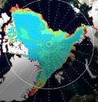
 The extent of the Arctic ice field can be observed on the large North Pole map. That map can be opened by clicking on the Polar region.
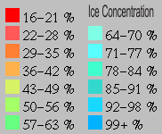
If polar bear Knut's cousins can still tread safely on ice and in which regions their habitats are threatened by melting pack ice, can be gauged with the help of the color scale.
The origin of the sea ice data is a satellite based passive microwave sensor. The Polar Ice Team of NOAA uses a NASA formula to derive their measurements.
The formula works by comparing the reflective properties of the various types of ice. Strong winds and heavy rains can falsify the data.
According to Russ Page (of the Anchorage WSFO) this happened for instance on 8 January 1997, when heavy 60 knot winds pounded the Bering Sea. In summer, sometimes puddles of water on the ice can lead to underestimating the ice thickness.
Data source : http://polar.ncep.noaa.gov/seaice/