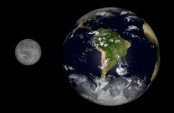
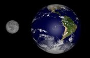
I made a cosmetic change to the display of the maps.
The standard "NASA Blue Marble Next Generation" maps have very dark oceans, as seen on the left.
You may have grown used to the dark, almost black, oceans, but it's not really the way the Earth looks. The new blue shade is shown below the old picture.
Satellite Look Up Tool is repaired
NASA changed the way in which its Spacecraft Master Catalogue is queried. The changes have been incorporated and the relevant pages are fixed.
2007-12-26
2007-12-02
Corrected error in the Global Warming index
There was a script error, which calculated the global warming wrong.
The now corrected script shows an above average temperature of +1.78 Celsius at the beginning of December, which is still a lot, but not as roastingly hot as the +11 something Celsius ...
2007-12-01
High temperatures at the beginning of December
The first December shows a Global Warming of 11.46 Celsius. It must be remembered that this means that the average temperature for the whole month of December is 11.46 C above average. The temperature will hopefully progressively fall until the end of December, because the planet is entering the winter season.
Exactly why this should be so, is not entirely clear to me, either. I suspect that there is more landmass in the northern half of the Earth than in the South. Or because there are more weather stations in the north to record the temperature.
Subscribe to:
Posts (Atom)